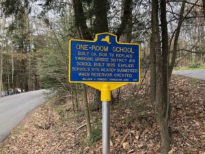
The “Swinging Bridge’ school was located along the Mongaup River, several miles south of the settlement of Mongaup Valley , which is situated along the Newburgh Cochecton Turnpike (Presently NY State Route 17B). The piece of property was deeded to this school, District #19 of the Monticello School District, in 1835. The location of the school on the southern edge in the town of Thompson allowed it to accept students from a short distance further south in the town of Forestburgh and a little west across the river in the town of Bethel. This is the only school we know of the children from three townships attended. The children in Bethel traversed a cable walking bridge over the river, giving the school and the area of the “Swinging Bridge” the name that is still used to this day.
We have no information about the community that it served, or any photographs of its students.
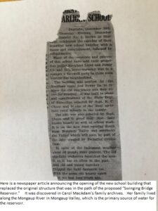
We do know that this school first existed in proximity to the river. During the 1920’s , as the region was experiencing rapid growth, additional sources of electricity were greatly needed. One of the local electric utility companies, Rockland Light and Power, announced plans to construct a series of reservoirs on the Mongaup River, most of which would include a hydro-electric generating facility just below each dam to accomplish its electrical infrastructure plans for this area of NY State. As a result, the section of the river valley that included this school would be flooded, and the school and neighboring houses and farms would need to be purchased, moved, or demolished. The school was re-located in 1929 approximately 100 yards east. The power company gave the school the property and built a new building that is the current house. The foundation of the original school building is underwater at the Swinging Bridge Marina.
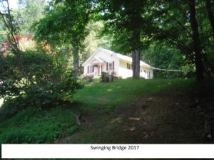
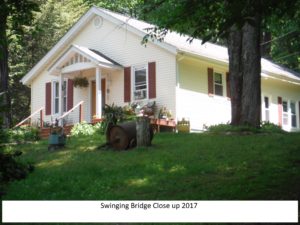
The school was closed and the property was sold in 1937. The building was remodeled into a single family home and has been meticulously maintained ever since, as shown in the photos below.
If you wish to visit the site, please refer to the map that is featured on this web site, or enter the following coordinates in to your GPS device:
| 41.627415, -74.779222 |